Sentiero Bernina Sud Alpine Route
Sentiero Bernina Sud
Welcome to the Sentiero Bernina Sud, SBS, Alpine Route, trail, marked as the SBS! The Sentiero Bernina Sud (SBS) is a new Alpine Route, only established as a marked route since 2019. It is the result of a partnership between the Valposchiavo , Bregaglia Engadin and Valenco Tourist Boards. They have worked with the Swiss hutte and Italian rifugio guardians (some are also Alpine Guides) on the Sentiero Bernina Sud to come up with a route that is exciting to follow. It also offers stunning views and a great variety in the terrain of the trail.
The SBS links a series of paths that circumnavigate the south side of Piz Bernina. Piz Bernina, at 4,049 metres is the highest summit in the Eastern Alps, towering on the border of Switzerland and Italy.
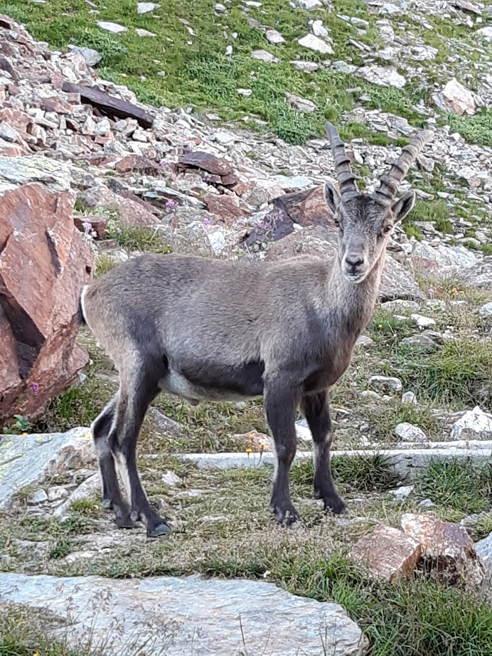
This route offers everything you would expect on an Alpine Adventure. From glaciers above and below to towering waterfalls and boulder fields to cross. There is a good chance of seeing eagles, Ibex and Chamois, all seen on previous walks on this route. Finally, some narrow, exposed paths with some chains and rungs for support (and your guide with his rope if needed).
Pictured: one of the steeper parts of the Sentiero Bernina Sud
‘Alpine Walks’ are proud to offer the Sentiero Bernina Sud as our first ‘open’ trip.
This means that you do not need to be a group to book this trip.
We presently offer this trip on the following dates, anyone is welcome to book a place.
The trips will run as long as a minimum of 6 people book on the following dates:
Saturday 24th June 2023 to Friday 30th June 2023.
Sunday 2nd July to Friday 7th July 2023
Saturday 3rd September 2023 – Friday 9th September 2023
Day 1 – Arrival at St Moritz, Switzerland
Meet at the Maloja Palace Hotel, in the small of town of Maloja. This is approximately a 35 minute bus ride from St Moritz Rail Station. After settling in you should meet your guide, who will run itinerary in more detail. Dinner at the hotel.
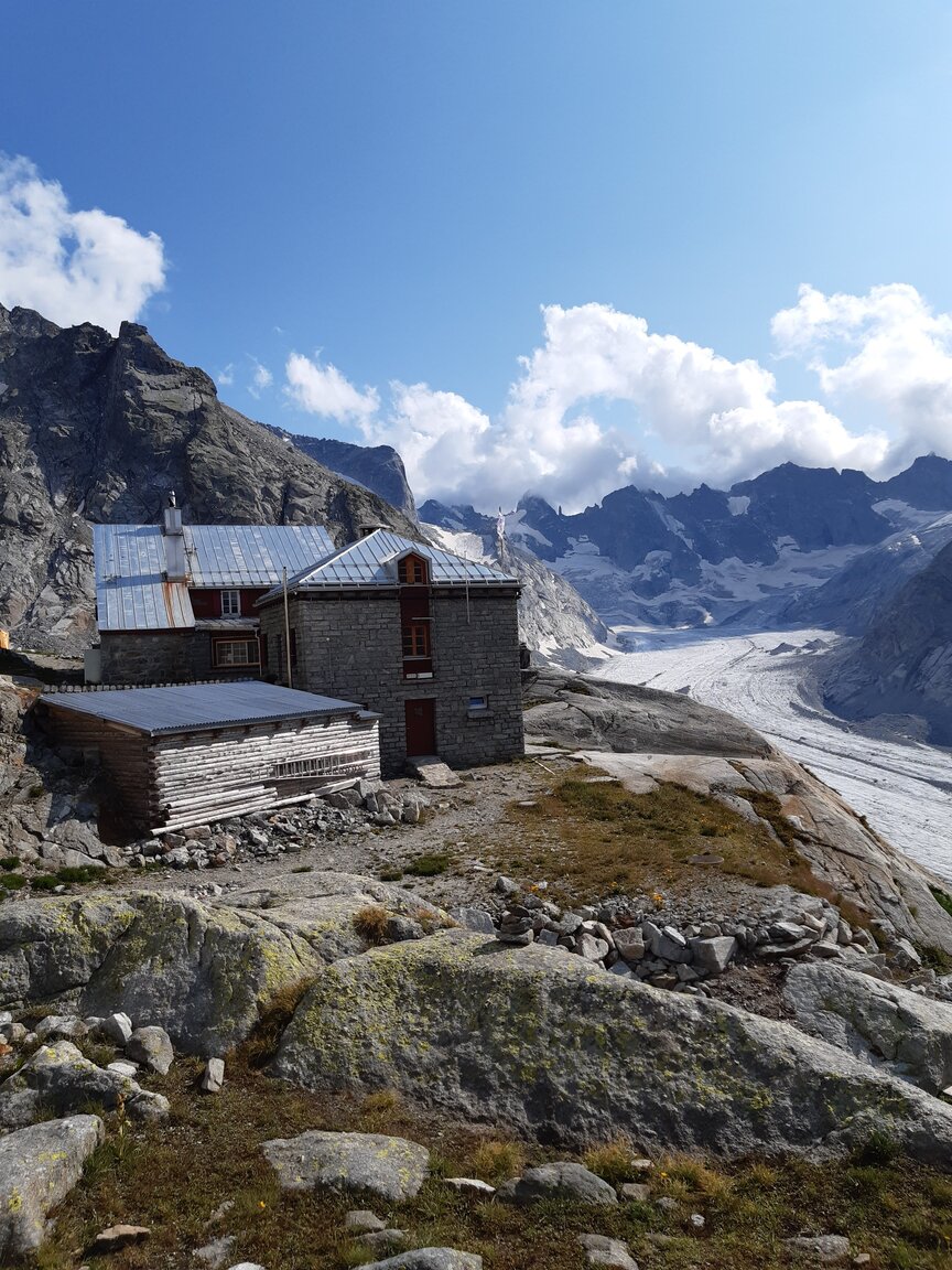
Day 2 – Maloja to Forno Hutte, Forno glacier
Leaving the hotel, we initially walk through alpine pastures before picking up the forest tracks that lead us in a southerly direction. There is a gentle climb up to the valley head where the Forno Valley and the Muretto Valley converge. From here we follow the glacial outflow, climbing gentle to a wooden bridge at the head of the Forno Glacier. Crossing the bridge, we then climb steeply up a good trail to gain enough height to contour along to reach our accommodation at the Forno Hutte
Distance: 12 Kilometres Height gain: 775 metres Time allowed : 6 hours
Day 3 – Forno Hutte, Switzerland to Rifugio Longoni, Italy
This morning begins with a short climb, crossing a boulder field up to ‘Selle del Forno’ (saddle of the Forno Valley). Ibex can frequently be spotted on this part of our journey. The saddle, at 2750 metres, is one of the passes joining Switzerland to Italy. We descend on a good path (750 height drop) to the ‘plain of the wolf’. After a lunch stop we begin to climb again. Initially on a forest track then, as we clear the tree line we climb up onto a plateau with waterfalls above. Soon the flag pole of the hut is sighted and we arrive at Rifugio Longoni
Distance: 12.75 Kilometres Height gain: 730 metres Time allowed : 7 hours
Day 4 – Rifugio Longoni – Rifugio Carate
Today begins with a short steep climb up to a little plateau offering stunning views Monte Braccia and Cima Del Duca. Continuing on narrow pathways (some chains and ladder rungs), we pass below the lower Scerscen glacier. Crossing a boulder field and climbing up to the Forcella d’Entova completes this section of uphill. We then drop into an ‘amphitheatre’ before once again climbing passing under the glacial outflows of Scerscen Superiore Glacier. The glacier is on the main southern slope of Piz Bernina summit. There is time to stop at the Rifugio Marinelli Bombardieri for drinks, before the last hour of walking. Heading steeply down, then another short uphill of 140 metres before a short descent to the tiny but warm welcome of Rifugio Carate.
Distance: 15 kilometres Height gain: 1050 metres Time allowed: 7 hrs 30 min
Day 5 – Rifugio Carate – Rifugio R. Bignami
We leave Rifugio Carate and head east for 5.5km, via the Forcella di Fellaria, a small coll at 2787 metres before a small decent to Rifugio R. Bignami for lunch. We stay here tonight, so after lunch there is the option to climb 500 metres to the southerly edge of the massive Vedretta di Fellaria Glacier at 2850 metres (descend by the same route back to the Rifugio)
Day 6 – Rifugio Carate – Porschiavo, Switzerland
From Rifugio Roberto Bignami, above the Lago di Gera we have a 520 metre climb to the final Col before the long descent back into Switzerland. Waving goodbye to the Piz Bernini massif we begin a 1600 metre descent to the town of Porschiavo and the end of our trek.
Height gain: 525 metres Height loss: 1903 metres Distance: 13.5 kilometres Total time: 7 hours
Our arrival at Porschiavo completes the walk and check into hotel accommodation. After dinner say farewell to your guide. The following morning you can get a train in the direction of St Moritz or head south to Tirano, in Italy, a short train ride away. From here trains connect for Lake Como and Milan.
Included:
- Guiding services each day
- 2 nights half board in hotels
- 4 nights half board in mountain huts
- Packed lunches each day
Excluded:
- Transfer to start point, Maloja, Engadin.
- Drinks with meals
- Transfer from end of trip, Poschiavo, Switzerland
Additional Information
Information on how to arrive at the start point of the trek from any airport/rail station will be included in your welcome instructions on receipt of booking. Likewise, return journey information will be included to get from Maloja back to St Moritz where trans depart for all cities where there are major airports in Switzerland.
£1,295.00 per person is based on shared twin/double room in hotel and group accommodation in huts. Single supplements are possible in hotels and some private rooms are available in huts upon request.
Dates available
This adventure runs from:
Saturday 24th June 2023 to Thursday 29th June 2023.
Sunday 2nd July to Saturday 7th July 2023
Saturday 3rd September 2023 – Friday 8th September 2023
If you have alternative dates in mind, just contact us and we will try to organise a tour to meet your requirements.
How fit do I need to be?
This trip is suitable for anyone who is a regular mountain walker. You will need to carry a medium sized rucksack (a maximum of 30 Litres in size) and the total weight based on the kit list provided should not exceed 10 kilograms.
How long will we be walking for each day?
You should expect to be trekking for 5-9 hours per day, based on a walking speed of 3 kilometres per hour, known to some as ‘Alpine plod’. It’s not a race and there is plenty of time for taking in the scenery and stopping for picnic lunches on route. The tracks and paths are rocky in places, but of good quality. There are some narrow paths throughout the journey which have a high level of exposure.
Can we customise the experience?
Alpine Walk’s guided walking tours are all about the personal touch. We will plan your journey along a range of different routes that provide different challenges based on what you want from your walking break. Do you want the best views? Do you want the chance to experience some of the local wildlife?
You should also consider the different types of accommodation available on these routes. Spending a night in a hut does not necessarily involve sharing a dormitory with 30 other people! Some huts have smaller private rooms.
So if you are considering this journey and need to discuss your requirements, please feel free to contact us. We’ll arrange a chat on Skype to discuss your personal tour.
Sentiero Bernina Sud alpine Route
£1,295 per person
Basic requirements:
- Min group size is 6 / Max group size is 8
- Suitable for anyone who is a regular walker carrying a medium rucksack (max 30 litres)
- You'll spend 5-9 hours walking per day at a moderate walking pace